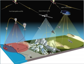
High-Altitude Pseudo-Satellites for PNT
DESCRIPTION
High-Altitude Pseudo-Satellites (HAPS) are airships “quasi-”stationed at a height of 20-30 km, in an altitude range where atmospheric winds are milder. HAPS are normally solar powered, unmanned, large, helium filled and semi-rigid; they can be operational for several years.
HAPS have been studied in the telecom domain (ESA GSP HAPPIEST study), where they were briefly considered as:
- An additional source of ranging signals (pseudo-satellite) in urban environments or deep valleys;
- A means to broadcast GNSS differential corrections, assisted data or SBAS data, at high latitudes, in deep valleys or in urban environments, as a gap filler with respect to current broadcast solutions (e.g. satellite or terrestrial networks);
- A means to enable advanced navigation applications and scientific research, such as GNSS reflectrometry, radio-occultation, ionosphere characterisation in areas with a low density of ground receivers (e.g. ocean).
HAPS may be competing with or complementary to other satellite solutions, such as LEO mega-constellations, inclined geosynchronous orbit satellites or simply multi-constellation or terrestrial pseudolites.
A number of distinct HAPS features with respect to other alternative PNT solutions are the following:
- Regional coverage, deployed where needed;
- Tens to hundreds of km of coverage per airship, i.e. much more than terrestrial pseudolites;
- Higher received power on ground than MEO and LEO;
- No ionosphere disturbance;
- Use of COTS components/subsystems;
- Re-usability and maintainability advantages;
- Support two-way navigation-related services;
- Short time-to-market.
HAPS face important technical challenges to be assessed, such as power supply, station keeping, time synchronisation and antenna pointing stability. On these issues, there have been significant improvements over the last few years, for instance regarding HAPS station-keeping performance by two leading European airship platform manufacturers.
The main objectives of this activity are to:
- Study the benefits of HAPS for GNSS augmentation in harsh environments, interference monitoring/location and alternative/complementary PNT;
- Study the different candidate architectures and downlink signal plans of HAPS for PNT objectives, possibly in combination with communication services/systems, assessing end‐to‐end system performance;
- Perform a HAPS PNT payload technology trade‐off;
- Perform a HAPS platform suitability assessment and high‐level requirements;
- Assess potential future demonstrations.
The tasks to be performed will include:
- Assessment of the benefits of HAPS with respect to other space-based or terrestrial systems for selected PNT objectives;
- Study and trade-off of the different HAPS functional architectures and downlink signal plans (UHF, L-, C-band and others) for the identified PNT objectives, possibly in combination with communication services;
- Detailed performance analysis of different HAPS functional architectures and configurations for PNT;
- Description of selected system concept(s) for HAPS for PNT;
- HAPS PNT payload technology trade-offs and high-level definition;
- HAPS platform suitability assessment and high-level requirements, considering available platforms and their expected evolutions;
- Assessment of potential future demonstrations for possible use in the definition of future activities and programmes.
The results of the activity will provide:
- Feasibility of HAPS for PNT for the selected objectives;
- Architecture of the HAPS system (phase 0 level);
- HAPS PNT payload high-level definition and platform constraints;
- Initial definition of future demonstrations.
esa-STAR link: http://emits.sso.esa.int/emits/owa/emits.main
