GNSS/non-GNSS Sensor Fusion for Resilience in High Integrity Aviation Applications
DESCRIPTION
GNSS technology has demonstrated its capability to provide very good performance in Europe up to LPV 200 based on GPS L1 (single frequency, single constellation) and is expected to reach CAT I Autoland with the future DFMC mode (Dual Frequency, Multi Constellations – GPS & GAL).
It is very challenging to improve this performance, more specifically the 6-second Time To Alert (TTA) that seems intrinsically difficult to reduce for space-based products.
Improving system resilience to external perturbing factors (signal occultation, jamming, spoofing, etc.) is also a very important contribution to offering better system availability and/or continuity.
Other R&D projects have addressed performance enhancement in the GNSS-only domain by augmenting a third constellation (in addition to GPS and Galileo).
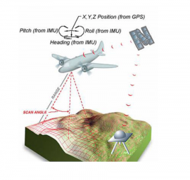
GNSS data and those from other sensors, such as barometers and inertial sensors, may already be combined in the avionics, however only after GNSS processing. The innovative approach proposed here is to combine GNSS data with other avionics measurements in the same integrity processing.
Sensor fusion is a promising path to overcoming performance limitations and improving the resilience of individual systems. A combination of GNSS with various types of additional measurements, ranging data (LIDAR, Vision-aided, TAWS) or non-ranging data (IMU) could improve in-flight awareness of airplane position and trajectory or could be used to mitigate continuity events, making for less stringent requirements for the design of individual systems.
A preliminary list of candidate sensors for fusion with GNSS comprises:
- IMU (Inertial Measurement Unit);
- LIDAR (Laser Imaging Detection And Ranging);
- Vision sensors (forward- and down-looking cameras);
- TAWS (Terrain Awareness Warning Systems).
The objectives of the proposed activity are to:
- Investigate the benefits of avionics sensor fusion in order to overcome the current limitations of GNSS (Protection Levels, Time To Alert, continuity, for example) and improve system resilience to external perturbing factors;
- Evaluate the impact this fusion would have on the user positioning algorithm.
The tasks to be performed will include:
- Identification and characterisation of on-board avionics sensors that could be used, distinguishing between airliners and light aircraft;
- Identification of the sensor added value (PL, TTA, availability, continuity, etc.);
- Identification of non-GNSS input bounding;
- Development of a new integrity monitoring and prediction concept to combine multi-source multi-sensor data;
- Impact assessment of receiver complexity;
- Prototyping of an innovative user positioning algorithm to handle additional ranging and non-ranging data from various avionics sensors;
- Characterisation of the achievable level of integrity and performance using synthetic and/or real measurements;
- Identification of the possible impacts of the sensor fusion on international PNT/GNSS standards.
Ultimately, improved airplane position and trajectory awareness could help to target more stringent flight conditions (CAT II, CAT III, etc.) and contribute to future plans to set up an in-flight demonstration with real-time measurements.
The outcome of the proposed study could also contribute to defining future PNT requirements, in particular for GNSS.
esa-STAR link: http://emits.sso.esa.int/emits/owa/emits.main
